Our mission is to provide high quality geo-information services and IT solutions based on satellite data. For our clients we offer a comprehensive and long-term support in developing their activities.
News
Radar module of the Fertisat service was awarded the Gold Medal of the POLAGRA PREMIERY 2024
We are pleased to announce that the radar module of Fertisat service has won the recognition of the Competition Jury composed of the top experts in the Polish agricultural community, and is among the Gold Medalists of the POLAGRA PREMIERY 2024 fair in Poznań!
The new module is based on satellite SAR (Synthetic Aperture Radar) imagery, which minimizes the dependence on weather conditions when generating application maps and allows to create accurate recommendations regarding doses of nitrogen, phosphorus and potassium. These functions enable farmers to optimize fertilization, saving production resources and improving the economic efficiency of farms. Development of the awarded solution lasted over 3 years and was co-financed by the Pomeranian Development Agency under the Regional Operational Program of the Pomeranian Voivodeship.
We thank the agricultural experts for their recognition, the sponsors for their support, and we encourage farmers and companies from the ag sector to visit our stand (No. 11, Pavilion 5A) on January 19-21, 2024, where you will be able to learn more about the new version of Fertisat service.
Presentation of new functions of Fertisat at Central Agricultural Fair and at POLAGRA PREMIERY Fair
We invite you to visit our stands at Central Agricultural Fair in Nadarzyn near Warsaw (December 8-10, 2023) and at POLAGRA PREMIERY Fair in Poznań (January 19-21, 2024). There will be an opportunity to see the new version of Fertisat service, in which we have implemented several new, very useful functions. One of them is a generator of application maps for nitrogen, phosphorus and potassium fertilizers based on analysis of satellite radar images. As radar data can be obtained regardless of weather conditions, we are now able to offer application maps at any time the farmer chooses. This is important in fully or partially cloudy conditions, which often make it difficult or impossible to acquire and analyse optical images during periods of intense field works.
Invitation to our stand at Agro Show Fair
Another event this year where we will be present is Agro Show Fair in Bednary near Poznań, organized on September 22-24. We invite you to our booth: No. 10 in the Exhibition Hall.
Our participation in the Potato Day and in the National Potato Fair
We invite potato growers, agronomists and everyone interested in Irriget and Fertisat services to visit our stands at the Potato Day organized by the Warsaw University of Life Sciences in Żelazna near Skierniewice on July 7 and at the National Potato Fair in Gronowice in Opole province on August 30-31 (stand N13).
Irriget service in its 2nd year of operation is already used by more than 200 Polish potato growers. During the events we will encourage more farmers to try out the service free of charge. For cereals and oilseed rape producers we also recommend Fertisat service, which provides maps of precise nitrogen fertilization, and from this autumn also calculators and maps of phosphorus and potassium fertilization.
Wasat’s management team is comprised of experts with multi-year professional background in satellite applications and IT sectors. The company cooperates with many universities and research institutions in Poland and abroad, it is equipped with the state-of-the-art software and research infrastructure and it provides clients with advisory services and training possibilities.
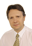
Bartosz Buszke
Managing Director
Bartosz graduated in management from the University of Gdańsk and received postgraduate diplomas in satellite applications domain, he was awarded with fellowships from the British Council and ESA. As a manager he worked in the Polish Space Research Centre and in Polspace. Bartosz was a member of the EU Space Advisory Group and now is a Board member of the Polish Space Agency. He is an expert in economics of satellite applications and in use of Earth Observation in agriculture, archaeology and the energy sector.

Dominik Ruciński
Remote Sensing Department Manager
Dominik graduated in geography from University in Lublin and completed postgraduate studies in remote sensing and GIS at the Military University of Technology in Warsaw. As a GIS expert he worked for several years in companies and public institutions in Poland. Since 2011 Dominik has been leading satellite imagery processing and analysis in Wasat, with a focus on agriculture, archaeology and environmental protection.

Daniel Zinkiewicz
Navigation and Geoinformation Department Manager
Daniel holds degrees in IT and geodesy from the University of Olsztyn where he received a governmental award for his Master thesis. He was employed as an geoinformation expert in companies in Poland and in Ireland. Since 2010 Daniel has been leading software development projects in Wasat. He is an expert in satellite data management, mobile mapping, GNSS and indoor navigation.
Remote Sensing Department
Department’s staff develops methods and algorithms that form the backbone of services offered to the agricultural and environmental protection sectors and to archaeologists. The team acquires advanced knowledge and technical skills during implementation of R&D projects, and through contacts with experts from the European Space Agency. This results in a high-quality work as well as in scientific publications and conference presentations.
Geo-informatics Department
The Department creates new methods of searching, processing and distribution of satellite data. It also develops mobile mapping applications and solutions for visualisation of spatial information. The tasks are implemented using modern and effective software development methodology based on standards promoted by international organizations.
Contact
Wasat Sp. z o.o.
Office in Gdańsk
Science and Technology Park:
ul. Trzy Lipy 3 (budynek B)
80-172 Gdańsk
Poland
Office in Warsaw:
al. Jana Pawła II 11
00-828 Warszawa
Poland
telephone:
+ 48 600 253 700
email:
office@wasat.pl
Send a message
